Skip to content
Earthquake Information

Earthquake Information

wiki.geodialog.com

  • Home
  • About
  • Glossary
  • Categories
    • Seismicity
    • Ground Motion
    • Hazard
    • SandBox
    • Earthquakes
    • US
    • Geodetic
    • Glossary
    • Tectonics
    • Subduction
  • Analytic Site
  • Toggle search form

Construct Regional Seismicity Models Using Geodetic Strain Rate

Posted on April 21, 2026April 25, 2026 By geoeditor

Analytical Tools

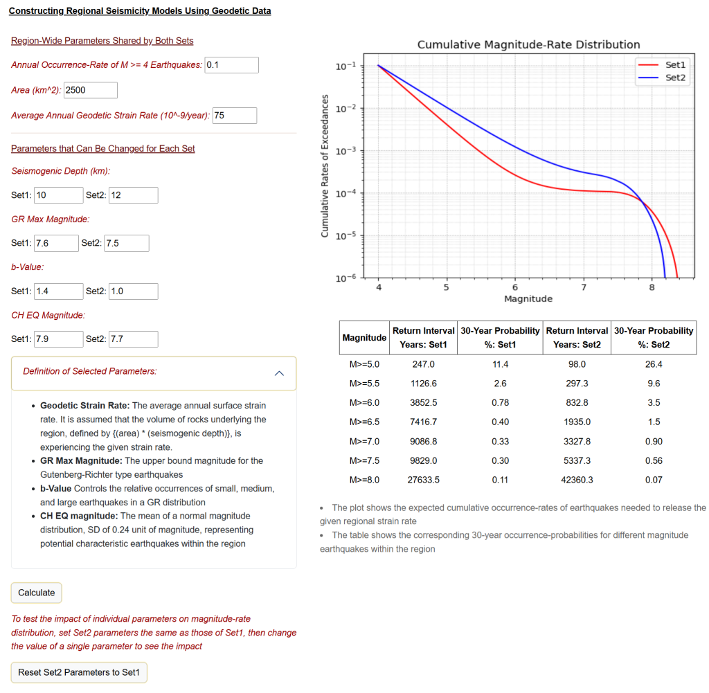
  • Sand Box: Construct Regional Seismicity Models Using Geodetic Strain Rate
  • Technical Details: Constructing Regional Seismicity Using Geodetic Data

Geodetic data provides valuable information on how a region is being strained and its potential to experience earthquakes. Over the last few decades, there have been concerted efforts to develop databases of global surface strain rates, aiming to assess regional earthquake hazards. Figure 1 shows a map of regional strain rates for Europe, as formulated by UNAVCO and GEM; see the document for more details.

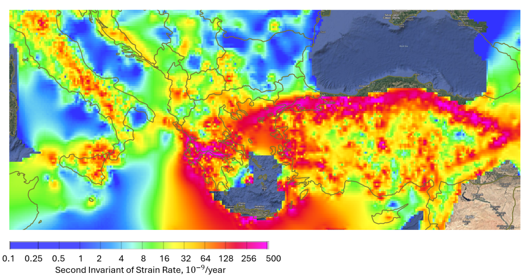
Figure 1. Geodetic strain rate map for Europe, created by UNAVCO and GEM

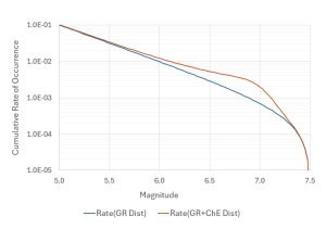
Many different studies have shown a strong correlation between the spatial distribution of earthquakes and surface strain rates. However, there are challenges in reliably interpreting regional surface strain rates to regional seismicity for hazard analysis, see the document link for more information. In spite of the challenges, most recent regional seismicity models use geodetic data to complement geologic, instrumental, and historic earthquake data to construct more robust seismicity models.

This page and the Sandbox are designed to discuss the hazard implications of geodetic data and to provide users a practical tool for constructing and evaluating regional seismicity models using geodetic strain rates.

$$\dot{\epsilon_{ij}}$$

Seismicity

Post navigation

Previous Post: Cascadia
Next Post: Seismicity of the United States

More Related Articles

Building Seismicity Model Seismicity
Characteristic Earthquakes Seismicity
Post Gutenberg-Richter Magnitude Rate Distribution: Technical Details Seismicity
USGS Earthquake Scenarios for Faults in Western US Seismicity
Geodetic Data and Regional Seismicity Geodetic
USGS Seismicity Model: Faults in the Western US Seismicity

All Posts

  • Building Seismicity Model
  • Cascadia
  • Characteristic Earthquakes
  • Comments and Suggestions
  • Construct Regional Seismicity Models Using Geodetic Strain Rate
  • Constructing Earthquake Scenarios for GM Analysis
  • Creating a Crustal Fault Database
  • Earthquake Ground Motion and Response Spectra
  • Earthquake Ground Motion and Response Spectral Analysis: Technical Details
  • Earthquake Hazard Analysis
  • Earthquake Hazard Issues and Analytical Tools
  • Geodetic Data and Regional Seismicity
  • Global Earthquake Distribution
  • Glossary List
  • Ground Motion Analysis for User-Defined Earthquake Scenarios
  • Ground Motion Components
  • Gutenberg-Richter Distribution: Technical Details
  • Interactive Modules
  • Post Gutenberg-Richter Magnitude Rate Distribution: Technical Details
  • Probabilistic Seismic Hazard Analysis: Technical Details
  • Sand Box Guide: Earthquake Hazard Analysis
  • Seismicity of the United States
  • Tectonic Plates
  • User-Based Global Earthquake Scenarios for Ground Motion Analysis
  • USGS Earthquake Scenarios for Faults in Western US
  • USGS Seismicity Model: Faults in the Western US

Copyright © 2026 Earthquake Information.

Powered by PressBook Premium theme