Skip to content
Earthquake Information

Earthquake Information

wiki.geodialog.com

  • Home
  • About
  • Glossary
  • Categories
    • Seismicity
    • Ground Motion
    • Hazard
    • SandBox
    • Earthquakes
    • US
    • Geodetic
    • Glossary
    • Tectonics
    • Subduction
  • Analytic Site
  • Toggle search form

Constructing Earthquake Scenarios for GM Analysis

Posted on May 5, 2025April 25, 2026 By geoeditor
  • Sandbox: Construct Earthquake Scenarios and Conduct Ground Motion Analysis
  • User Based Global Earthquake Scenario Page

The following briefly discusses constructing an earthquake scenario using a user-defined fault database. For details, see Create Crustal Fault Database.

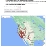
It is assumed that a fault database is created using Construct Earthquake Scenarios and Conduct Ground Motion Analysis sandbox or other means outside the program. As shown in Figure 1, the user-stored segment data is copied into the textbox. The “Register Data” button will register the database within the program, reformatting it to a more readable format (see Figure 2). In this example, Figures 1 and 2 show data and the plot for two hypothetical faults near Tabas, Iran.

If the registered database includes data from geographically far-apart regions, the initial map is not focused on any particular segment. Use the “Center Map” button with proper coordinates to center the map on any desired location.

The user can define an earthquake scenario by entering the ID of the participating segments, comma-delimited, in the earthquake scenario textbox. The segments in the database must have unique IDs. Otherwise, the program will define the earthquake scenario using the first encounter IDs from the database.

The “Estimate Magnitude” button estimates the expected magnitude for the scenario using the total rupture area and length following the procedure used by the USGS for crustal faults in the western US in their 2023 model. The user can modify the magnitude if necessary.

The “Estimate Ground Motion” button takes you to the ground motion page for GM analysis. See the documentation, Ground Motion Analysis, for details.

Figure 1. Copy segments’ data, with compact format, to the textbox to create a database within the program for constructing earthquake scenarios

Figure 2. The compact segments’ data must be registered by the program to be usable. After registering, the textbox will display segments in a more readable format. Also, it adds the expected magnitude to each segment if it ruptures by itself. Define an earthquake scenario by adding comma-delimited IDs to the scenario textbox.

Earthquakes, Ground Motion

Post navigation

Previous Post: Creating a Crustal Fault Database
Next Post: User-Based Global Earthquake Scenarios for Ground Motion Analysis

More Related Articles

User-Based Global Earthquake Scenarios for Ground Motion Analysis Ground Motion
Earthquake Ground Motion and Response Spectra Ground Motion
Creating a Crustal Fault Database Earthquakes
Earthquake Ground Motion and Response Spectral Analysis: Technical Details Ground Motion
Global Earthquake Distribution Earthquakes
Ground Motion Analysis for User-Defined Earthquake Scenarios Ground Motion

All Posts

  • Building Seismicity Model
  • Cascadia
  • Characteristic Earthquakes
  • Comments and Suggestions
  • Construct Regional Seismicity Models Using Geodetic Strain Rate
  • Constructing Earthquake Scenarios for GM Analysis
  • Creating a Crustal Fault Database
  • Earthquake Ground Motion and Response Spectra
  • Earthquake Ground Motion and Response Spectral Analysis: Technical Details
  • Earthquake Hazard Analysis
  • Earthquake Hazard Issues and Analytical Tools
  • Geodetic Data and Regional Seismicity
  • Global Earthquake Distribution
  • Glossary List
  • Ground Motion Analysis for User-Defined Earthquake Scenarios
  • Ground Motion Components
  • Gutenberg-Richter Distribution: Technical Details
  • Interactive Modules
  • Post Gutenberg-Richter Magnitude Rate Distribution: Technical Details
  • Probabilistic Seismic Hazard Analysis: Technical Details
  • Sand Box Guide: Earthquake Hazard Analysis
  • Seismicity of the United States
  • Tectonic Plates
  • User-Based Global Earthquake Scenarios for Ground Motion Analysis
  • USGS Earthquake Scenarios for Faults in Western US
  • USGS Seismicity Model: Faults in the Western US

Copyright © 2026 Earthquake Information.

Powered by PressBook Premium theme