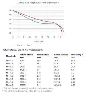
Building Seismicity Model
Analytical Tools Constructing a seismicity model, in a nutshell, means formulating a realistic model of earthquake occurrences on a fault, in a subduction zone, or within an area. A modeler would collect: Most seismicity models are formulated as a combination of a Gutenberg-Richter (GR) and a characteristic earthquake model. The Gutenberg-Richter model describes the occurrence…