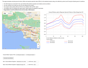
Interactive Global Distribution of Earthquakes and Tectonic Plates
Earth’s surface is not a single unbroken shell but a mosaic of tectonic plates that slowly move over the planet’s interior. Where these plates meet, they interact in powerful ways: some collide and force one plate beneath another, some pull apart to create new crust, and others slide laterally past each other. These boundaries are the engines of global seismicity. The stresses generated by plate motions accumulate over decades to centuries, eventually releasing as earthquakes — sometimes shallow and destructive, sometimes deep within the mantle, and sometimes in long, quiet stretches between major events.
The global distribution of large earthquakes reflects the fundamental architecture of plate tectonics. Most high‑magnitude events occur along plate boundaries, where long‑term strain accumulates through relative plate motion and is released episodically through brittle failure. Subduction zones dominate global seismicity, producing both shallow megathrust earthquakes and deep‑focus events that extend to ~650 km within the descending slab. Transform boundaries generate linear belts of strike‑slip earthquakes, while divergent margins host more diffuse seismicity associated with extensional faulting. In contrast, stable continental interiors experience low strain rates and correspondingly few large earthquakes, underscoring the strong spatial variability of lithospheric deformation.
The distribution of large earthquakes are far from random. They trace the geometry of plate boundaries with remarkable clarity: the deep arcs of subduction zones, the linear scars of transform faults, and the spreading centers that mark mid‑ocean ridges. By studying where earthquakes occur, how deep they are, and how their patterns change through time, we gain insight into the dynamic processes shaping our planet.
This interactive map is designed to support that exploration. Using a global catalog of earthquakes with magnitudes \(M \ge 6.0\) from 1700 to the present, the tool allows you to filter events by magnitude, depth, and date to reveal the underlying structure of seismic activity. You can also overlay major tectonic plate boundaries to see how closely large earthquakes align with the fundamental architecture of plate tectonics. The result is a clear, data‑driven way to investigate how Earth’s plates interact and generate the seismic patterns we observe today.